Overview
The Auden’s Col Trek is one of the toughest treks in India as there are many steep climbs and involves long hours of walking. It is located in the Uttarkashi district of Uttarakhand and connects the Gangotri Valley to the Kedarnath Valley. The Auden’s Col Trek begins at Gangotri and ends at Gaurikund. The entire trek is around 85-100 km and takes 15 days to complete. It is an extremely difficult trek and requires technical mountaineering skills. June and September are the best time to visit Auden’s Col Trek as the temperatures are comparatively favourable and the weather is good. The trek got its name from the British poet W.H. Auden. He was a travel enthusiast and explored this route for the first time in 1936.
Highlights
- 5% GST will be applicable on Trek Cost and Add-ons.
Itinerary
We will start our drive from Dehradun to Gangotri. As you know it is one of the most religious places in India. You will cross Uttarkashi, the place having the NIM mountaineering institute. Uttarkashi is a town located on the banks of river Bhagirathi. The drive goes through temples and dense forests until you reach in the evening.
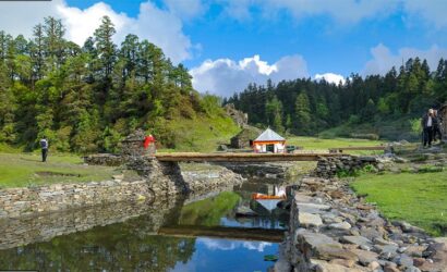
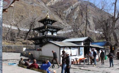
Gangotri is also situated on the banks of river Bhagirathi. It is one of the Char Dhams, hence, it sees a huge crowd of pilgrims in March and April. There are also many foreigners visiting. You can also roam in the market and get acquainted with the locals. But, leave that for the next day and rest in your hotel.
Morning Wake up by sounds of bells in the religious land. Today try to utilize the day to know about Gangotri. You can visit temples, caves, walk in the woods, meet Sadhus, etc. Together with the group, you can visit Surya Kund, Pandav Gufa and GauriKund also. Try not to miss the Evening Aarti. Today is acclimatization day so stay outdoors and get used to the height.
After acclimatization stay in Gangotri, and get walk towards Nala Camp. The trek will of 6-7 hours through the moderate and steep trail. You begin by going down the main valley. You will be walking along the Bhagirathi River. After 2 km cross the log bridge on the river then take a right to enter Rudragaira valley. You will be walking through dense Pine, Cedar, Rhododendrons, and Birch trees.
The trail then suddenly climbs up. You may also have to pass through the rockfall zone, so be careful. As you gain height you can see the forests becoming less visible. Later you can find grasslands bloomed with flowers. You can also see a glimpse of Gangotri III and Jogin II. The campsite is on the wonderful meadows beside Rudragaira river. So, enjoy it while your night stays in tents.
Today somehow our entire trail is a steep and strainful climb. There will be no water sources on the way. Make sure you carry enough water. Moving through Nala the trail will go up towards high meadows.
There will be many stream crossings and landslide crossings. Take your steps carefully. Ahead you may find some snow patches and the trail getting even steeper. Despite all the difficulty, your day will be cheerful with the stunning sights of Rudragaira Peak, Jogin Peak and Auden Col pass. After a strenuous day rest in your tents at Rudragaira camp.
Since you are at 14300 feet it is necessary to give your body the time for acclimatization. Explore the campsite. Make the most of this stunning campsite that is between huge peaks on meadows beside a gushing river. If you wish to you can go for a small hike on a ridge near the campsite. Try to stay out of the tents to boost the process of acclimatization.
We will start our walking on moraines. Once you cross a landslide area you will reach the top of the ridge. Keep walking on the ridge and climb down till Bakriwala camp. After crossing a stream another ridge will come ahead. This ridge is a flat like a walk for more than an hour. The walk is tricky owing to loose scree, hence, be careful. Once you finish the ridge you will have a descend ahead.
Descent down to Gangotri Base camp. After a climb, you will be welcomed by SukhaTaal. It is a surprise element of the trek. Base Camp is on flat moraine surface. From the camp, you can see the gully leading to Audens Col.
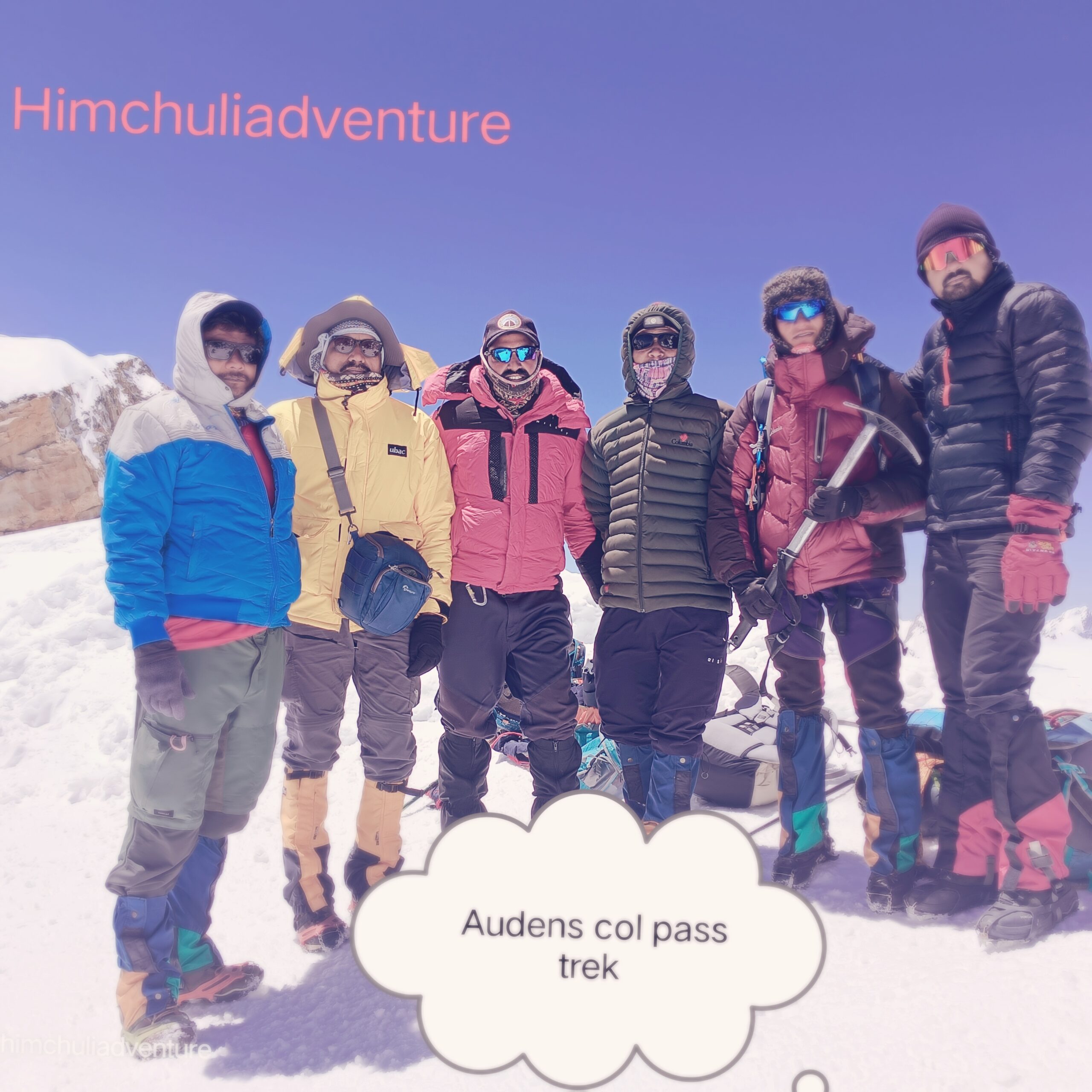
Today will be the longest, toughest, and most exquisite. Since days you were hoping of crossing Audens col and today it will be done. Start by walking on the moraine, you can see Rudgragaira glacier on the right. There is a couple of snow-laden ridges following. Based on the snow level you might be instructed to wear crampons. After crossing the last ridge you will climb up a little to enter the gully.
The flat ground that comes next is used as Advanced camping site. The climb up henceforth requires roping up. When you are getting for Audens pass you can see many crevasses, you might have to cross over one or two. Therefore, follow your guide's footsteps. The snow level also may increase to knee-deep. At this height, it becomes difficult to walk. With Jogin and Gangotri peaks towering on the sides,70-degree the Audens col looks exceptional.
The views on the other side are even more stunning. You can see Khatling Glacier and its crevasses giving an instant wave of fear. The climb down is extremely steep with 70 degrees’ slope. The descent is scary after comes a flat glacier ground. You will be camping on this moraine land of Khatling Glacier.
Today we will continue on the rest of the Khatling glacier to arrive at Zero Point camp. The initial 50 m is a steep descend. Watch your steps. The trail will be covered with snow. Climb down the glacier for another 2 km to reach the moraines.
The trail is filled with loose rocks and scree. The route is also exposed and you can see black ice, icefall, and big ice formations. You will also have to find way through crevasses. From the end of Khatling glacier from the snout, Bhilangnariver originates. Cross the last section of the rockfall and boulder section to reach the campsite.
Mandatory Rest day.
Rejuvenate yourself.
This day also can be used as a buffer day.
This is a purposefully added day for resting. After all the strainful and amazing trek experiences, take rest for this day. This day can be also used as a buffer day in case of unfavourable situations.
After the rest day, you will be fully energized to start a wonderful day. Today will be a nice and pleasant walk through the meadows. Continue walking along the valley for 3 km. You will be crossing a wooden bridge on the fiercely flowing Bhilangariver. After that, the lush meadow will welcome you. You can take a break here to relax on the beautiful meadows.
Keep walking for another 4km to the next campsite. The Chowki campsite is a beautiful setup on the huge grasslands between big mountains.
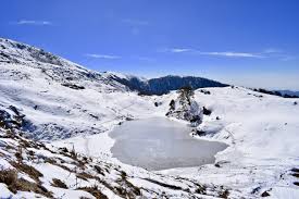
Today you will gain a little height to reach the crystal, Masar Tal. The day will be rejuvenated by clear views of Thalaysagar peak. The trail begins with a small ascend showing sights of Thalaysagar. You cross another few ridges. You will also cross a stream until you reach the beautiful Masar Tal. The lake reflects the scenery around it thousand times. You will be lucky to camp beside this lake.
Today you will visit another and the last pass of the trek, Mayali pass. The trail starts with a climb up over boulders to the Masar top. A climb up for another 45 minutes is needed to reach the base of the pass. This point is outstanding in terms of beauty. There is a lake which is at times semi-frozen with ice bergs floating on its surface.
After this a long walk is followed. The trail is somewhat flat and gradual. You will also be crossing crevasses just like at Khatling but a lot easier. The top of the pass gives a feeling victory. Enjoy for a moment then start to descend. The climbing down trail is filled with boulders and is steep. Before this you may spot the Peenya Tal twin lakes. Keep walking ahead to reach the Vasuki Tal.
Finally the day has arrived that will reach at the mighty Kedarnath. It is one of the Char Dhaams and one of the 12 Jyotirlingas. It has a lot of prime importance in Indian religion. First, start with a ascend to Vasuki Tal top. The trail is boulder filled ridge walk.
After this point there is a steep descend continuously. You will be excited to finally see the greenland. The Kedarnath village beside Mandakiniriver looks serene. Enjoy your evening with the blessing of Lord Shiva.
This is the final stroll of the thrilling trek. It is a complete long climb down of 14kms. The trail is an easy and well-marked. Try to engulf the most from the last day in the mountains.
It’s the last day of the trek and time to go back to the lovely home. After boarding the pickup vehicle you will arrive in Rishikesh completing a long journey.
Note:
Keep a buffer day in your travel plan
If buffer day is not used in the travel then it can be used to Explore Rishikesh
Read the article Things to do in Rishikesh
Distance, Altitude, and Trekking hours are approximate and rounded off
Keep the original and copy of ID proof handy
Come one day early if planning to come by plan
Includes/Excludes
Cost Includes
- Accommodation (as per the itinerary):
- Guest houses on (twin/triple sharing basis).
- Camping during the trek.
- Meals (Veg + Egg):
- All meals Gangotri to Gaurikund.
- 1 Versatile base camp manager: handles communication and deploys extra manpower in emergencies.
- 1 Mountaineering & First aid qualified professional trek Leader.
- 1 Experienced high altitude chef.
- Local experienced guides (Number of guides depending on the group size).
- Sleeping bag, Sleeping liners (if required), Mattress, Utensils.
- 3 men all season trekker tent (twin sharing), Kitchen & Dining tent, Toilet tent.
- Camping stool, Walkie talkie.
- Ropes, Helmet, Ice axe, Harness, Gaiters & Crampon (if required).
- Medical kit, Stretcher, Oxygen cylinder, Blood pressure monitor, Oximeter, Stethoscope.
- Transportation (as per the itinerary)
- Mules/porters to carry the central luggage.
- All necessary permits and entry fees, up to the amount charged for Indians.
- Services from Gangotri to Gaurikund.
Cost Exclusion
- Insurance (Mandatory).
- Food during the transit.
- Extra Food and Drinks.
- Any kind of personal expenses.
- Mule or porter to carry personal luggage.
- Emergency evacuation, hospitalization charge or etc.
- Anything not specifically mentioned under the head Inclusion.
- Transportation (Dehradun to Gangotri and Gaurikund to Rishikrsh).
- Tips for Guide and porters. (Expected )