Trip info
-
may to mid July , sep to nov
Overview
Starting Point: Mana Village (approximately 3 km from Badrinath)
Ending Point: Badrinath
Duration: 6 to 9 days
Distance: Around 40–47 km round trip
Max Altitude: 4,600 meters (15,091 feet)
Difficulty Level: Moderate to Challenging
Best Time to Trek: May–June and September–October
Highlights
- 5% GST will be applicable on Trek Cost and Add-ons
- Services joshimath to joshimath
- Drop Time: 6:30 pm to 7:30 pm (Timings are subject to change based on weather and road conditions).
- Please reach Rishikesh a day before to avoid any delays.
Itinerary
Altitude: 1,800m/6050ft.
220 km drive, approx 10 hours.
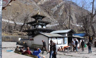
Drive From Rishikesh To joshimath
Trekkers will be picked from Rishikesh at 6:00am in a Tata Sumo or a similar vehicle (cost is not included).
Arrive at Joshimath approx by 5 pm – (tea, briefing of the trek & dinner).
Breakfast and Lunch on the way (exclusive of charges).
Accommodation at the guest house.
Telephone Network- Available.
Transportation is not included in the cost.
This is the first day of your journey and it commences from Rishikesh. Our representatives will pick you up from Rishikesh and drive you all the way to Joshimath. The journey takes you on a picturesque ride alongside the Bhagirathi River. Joshimath is about 220 km away from Rishikesh and it takes about 9 to 10 hrs to reach Badrinath depending on the weather and road conditions. Along the way, you also get to see the confluence of the rivers Alaknanda and Bhagirathi which merge together at Devprayag and flow as one in the form of Ganga.
On reaching Joshimath we will check into a hotel and rest for the night giving the body enough time to acclimatize to the high altitude. You can take a preventive course of Diamox to help your body acclimatize faster to the higher altitudes.
Altitude: 11,900 ft.
Drive Distance (Pipalkoti to Mana): 80km
Drive Time: 3-4 hrs
Trek Distance: 7-8 km.
Duration: 5-6 hrs.
Drive to Mana via Badrinath and trek to Lakshmi Van
Witness the 400 ft tall Vasundhara Falls.
Sight the Alkapuri Glacier from where Alaknanda originates.
Stay in tents (twin-sharing).
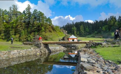
We will start the trek early in the morning as we have to drive a distance of 80 km today to mana. From mana, it is 7-8 km to Lakshmi Van. Mana is considered the last village in India and lies 26 km from the Indo-China border. You can also spot the road that goes to the border, although it is restricted only to people belonging to the army. Here you will have your permit checked before you continue on towards Laxmi Van. From Mana village, you will spot a trail that deviates towards the left of the Alaknanda River and for 2 to 3 km the trail is well-paved. About 3 km from the village lies the Vasundhara Falls, a 400 ft waterfall cascading down in white sheets of water. Vasundhara falls is a popular spot among tourists. The locals believe that the water of the falls as well as the Alaknanda River has medicinal value and many people store water from these water sources.
You can fill your water bottles from the waterfall. Keep hydrated as you will slowly gain altitude. After you cross the waterfall continue on the left bank of the river. You will now walk on moraines for the next 3 hrs and soon you will reach the Laxmi Van campsite. Laxmi Van campsite is located at an altitude of 11,900 ft and is covered with green and well-shaded by Bhoj Patra trees. From the campsite, you can see the Alkapuri Glacier, the source of the Alaknanda River. The glacier is situated at the base of the Balakun peak and you can witness the river flowing from the snout of the glacier. Overnight stay will be in tents.
Altitude: 13,658 ft.
Trek Distance: 7 km.
Trek Duration: 5-6hrs.
Stay in tents (twin-sharing).
Lakshmi Van To Chakrateertha
Today’s trek is slightly more difficult than the previous day as you will gain more than 2000 ft of altitude. Even though the route is difficult but it becomes quite scenic as you enter the Satopanth Valley. The trail again follows the bank of the Alaknanda River and we will walk on a patch of grassland passing along the middle of the terminal moraine of Dhano Glacier. Once you cross this patch, the view of Bhagirathi peaks begins to open up in front of you. Although the peaks are visible only if the weather is clear.
Trekking for about 5 km, you will reach another gorgeous waterfall called Shastradhara and from here you can spot Mt. Neelkanth on your left. Shasatradhara is a culmination of more than 100 small waterfalls, streaming down a huge monolith. Weather can be quite unpredictable here post noon so we will try to begin our trek as early as possible. Chakrateertha Campsite is about half an hour away from this spot.
The campsite lies on a flat patch of a clearing. This is where we will pitch our tents for the night. Make sure you have enough warm layers on and cover your head properly. The temperature here during the daytime is 5°C to 10°C and at night it can stoop down to 0°C to -5°C. It is also important to check signs of altitude sickness at this altitude. If you are showing signs like headache, nausea, loss of appetite, fatigue, or dizziness then you should report to the Trek Leader immediately. Tonight we will camp amidst greenery and towering peaks.
Altitude: 14,258 ft.
Trek Distance: 10 km (5 km on each side).
Trek Duration: 8 hrs.
Stay in tents (twin-sharing).
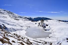
Chakrateertha To Satopanth Tal And Back
Today is one of the most exciting as well as the scenic day of the trek. Today you will trek to the mystical Satopanth Lake. Wake up to a wonderful mountain view with Mt. Chaukhamba in the center, Mt. Nelekanth on the left, and Mt. Balakun on the right. This view will stay in your mind for a long time.
The trek starts with an easy gradient as you walk on a flat grassland and after about 2 km the trek snakes around boulders and moraines. This can be a tricky section and you need to be very cautious as you navigate around this zone. Trekking poles can be of good help here.
Continue walking on the ridge, Satopanth Tal isn’t visible until you reach the top of the ridge. With a perimeter of over 1 km, the lake is simply huge. It is triangular in shape and as the legends go, it is believed that the trinity Brahma, Vishnu, and Mahesh meditated on the three corners of the lake. You can also see a small shelter made of stone near the lake. A local sage by the name of Mauni Baba is said to live here.
The lake is bluish in color and an interesting fact about Satopanth Lake is that the water of the lake remains clear all year round. Also on a clear day, you can see three out of the seven steps of the Swargarohini Glacier. It is believed that the Pandavas followed these steps to ascend into heaven.
Sit around the lake, admire its beauty and enjoy its serenity for some time before you make your way back to the Chakrateertaha Campsite. It takes about 2 to 3 hrs to descend down to the campsite from the lake.
Chakrateertha To Mana and drive to Badrinath
Drive: 290 km, approx 10-11 hrs.
Ride will commence at 6 am, reaching the destination at around 6 pm.
Breakfast and Lunch will be on the way at a roadside inn, exclusive of charges.
Return transportation is not included.
Badrinath To Rishikesh
The beautiful time in the mountains ends today as you will be driven back to Rishikesh. Wake up early and have a delicious breakfast post which we will start our drive towards Rishikesh.
The drive will be along the same scenic routes where you can reminisce about your journey. It will take 9 to 10 hrs approximately to reach Rishikesh. You can expect to reach Rishikesh by 7 PM.
Note:
- Keep a buffer day in your travel plan.
- If buffer day is not used in the travel then it can be used to Explore Rishikesh.
- Read the article Things to do in Rishikesh.
Includes/Excludes
Cost Includes
- 1. Accommodation (as per the itinerary):
- Guest house in Pipalkoti (Day 1 and Day 2 as per the itinerary).
- Camping while on trek (twin sharing).
- 2. Meals (Veg + Egg):
- All meals (including tea, soup, snacks, etc.) from Day 1 Dinner to Day 5 Dinner.
- 3. Support:
- 1 Versatile base camp manager: handles communication and deploys extra manpower in emergencies.
- 1 Mountaineering & First aid qualified professional trek Leader.
- 1 Experienced high altitude chef.
- Local experienced guides (Number of guides depending on the group size).
- Enough support staff.
- 4. Trek equipment:
- Sleeping bag, Sleeping liners (if required), Mattress, Utensils.
- 3 men all season trekker tent (twin sharing), Kitchen & Dining tent, Toilet tent.
- Camping stool, Walkie talkie.
- Ropes, Helmet, Ice axe, Harness, Gaiters & Crampon (if required).
- 5. First aid:
- Medical kit, Stretcher, Oxygen cylinder, Blood pressure monitor, Oximeter, Stethoscope.
- 6. Transportation (as per the itinerary):
- Rishikesh to Pipalkoti & return.
- 7. Mules/porters to carry the central luggage.
- 8. Cloakroom facility available at the base camp for additional luggage.
- 9. All necessary permits and entry fees, Upto the amount charged for Indian.
- 10. Services from joshimath to joshimath.
Cost Excludes
- 1. Insurance (Mandatory).
- 2. Food during the transit.
- 3. Any kind of personal expenses.
- 4. Mule or porter to carry personal luggage.
- 5. Emergency evacuation, hospitalization charge or etc.
- 6. Anything not specifically mentioned under the head Inclusion.
- 7. Transport cost.
- Things can be provided on demand and availability (participant has to pay extra for these things).
- 1- Satellite phone/set phone - is a type of mobile phone that connects via radio links via satellites orbiting the Earth instead of terrestrial cell sites like cellphones. Therefore, they can operate in most geographic locations on the Earth's surface.
- 2- Gamow/PAC HAPO Bag (Portable Hyperbaric Bag) - is a unique, portable hyperbaric chamber for the treatment of acute mountain sickness (AMS), also known as altitude sickness.
- 3- AEDs (Automated External Defibrillators) - are portable life-saving devices designed to treat people experiencing sudden cardiac arrest, a medical condition in which the heart stops beating suddenly and unexpectedly.